
Note: So. Hey everyone. I really got bad about writing these posts while I was actually on trail. For future hikers out there, take note. Keeping a blog up-to-date while on trail is much harder than it looks. Kudos to all those bloggers who actually kept up with it.
If you followed me on Instagram (which I turned out to be much better at keeping up with), you’ll know I finished the trail back in November. Then I had to get used to being back in the real world, find a job, yada yada. If I’m being honest, those are all just excuses. I didn’t want to get back to writing this blog because I knew how much it would make me miss the trail, so I’ve just been putting it off. But, my mom and her friends have been bugging me, so I thought I’d finally dust off the ‘ol keyboard and tell you all of my grand adventures down south. Enjoy, but fair warning: taking this long to get back to writing means I’ve probably forgotten a lot of the details. Hopefully my pretty pictures will make up for it.
Miles 1333.3 – 1555.0
9/21/19 – 10/3/19
Day 106: 22 miles
Paul C. Wolfe Shelter to Harpers Creek Shelter
Got started in the dark again this morning. It was only dark for a little bit though before I started to get some beautiful colors from the sunrise on the mountains.


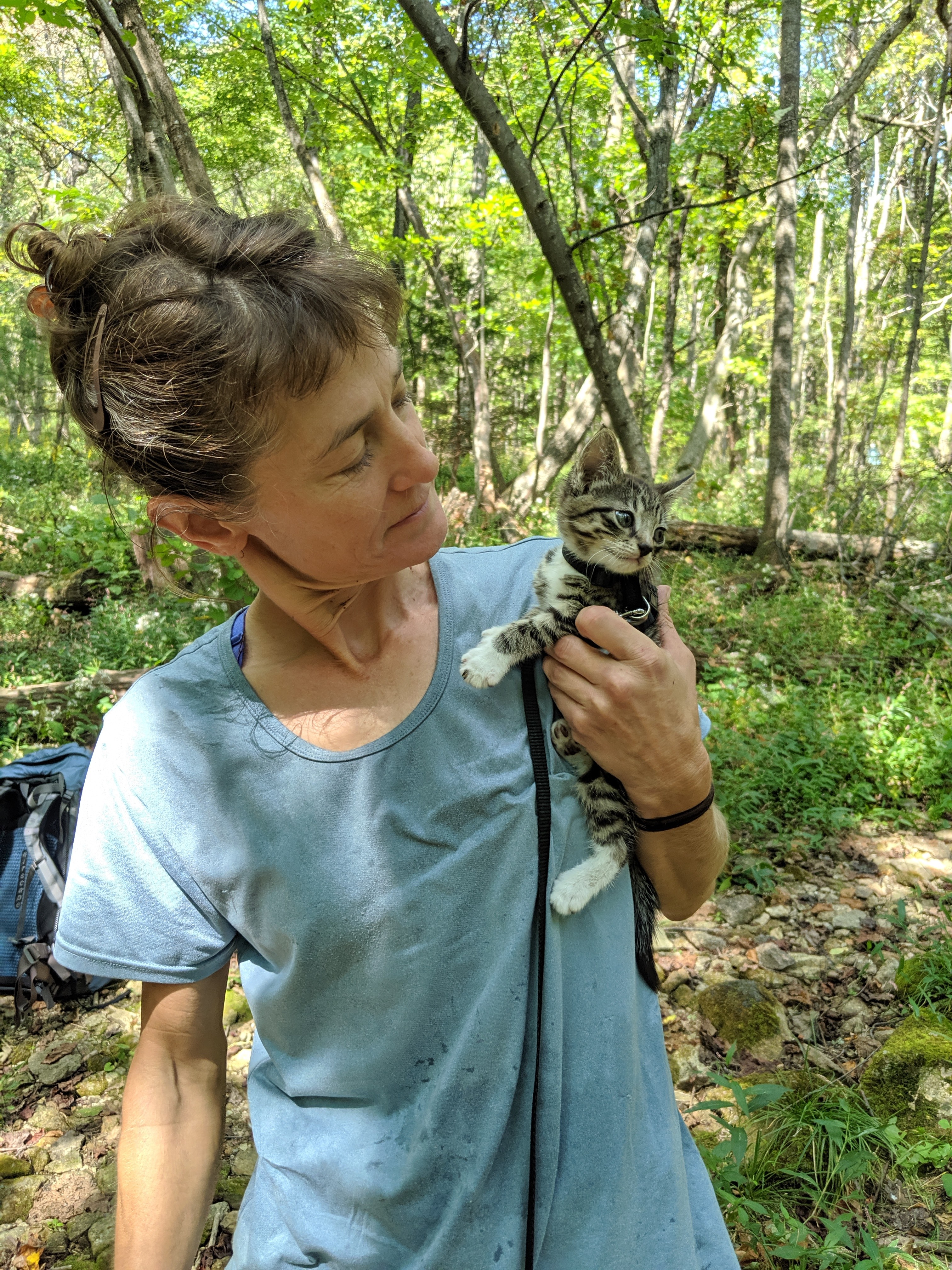
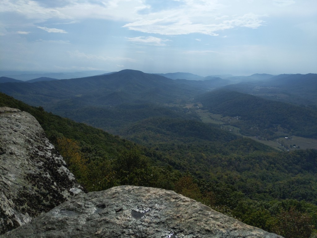
I stopped for lunch on a rock with a pretty nice view, and then stopped to get water at a shelter around mile 15. At the spring at the shelter, I met my favorite hiker ever, a tiny kitten on a leash named Avery. Her mama said I could pet her as long as I hadn’t been around any cats recently, since she hadn’t gotten her shots yet. Needless to say my water break took a little bit longer than I originally planned.


After the water, it was a long climb up to the Three Ridges and a steep downhill after that. By the end of the day, I was getting really physically exhausted, which always makes me more emotionally exhausted, so I had a good cry on trail. I really don’t like the heat, and it was oppressive today. Ended up at a shelter with lots of weekenders camping around but no thru-hikers.

Day 107: 16.9 miles
Harpers Creek Shelter to stealth campsite
I woke up to find my socks, which I had lying on my shoes overnight to dry, had been murdered during the night by some mice. Very rude. I carry two pairs of hiking socks though, so I just put on the other pair and hoped that Darn Tuff would accept mouse-chewn holes under their warranty program.
Started the day with a long uphill to the top of the Priest, where I confessed my trail sins in the trail log at the shelter and read some other people’s confessions while I had a break. A lot of people do not dig their catholes deep enough, apparently.


I then headed to a river/stream where I was originally going to camp, but the stealth site listed on Guthooks didn’t really exist, or at least wasn’t obvious to me, so instead I filled up on water and just headed back on the trail for about a mile or so more until I found another stealth site. At camp, the tiny adapter which allowed me to charge by USB-C phone with a micro-USB cord broke after only charging my phone to about 50%. Since I was hiking all alone at that point, not having the ability to message people when I had service or even hear a human voice from a podcast made me get real emotional. I knew I was heading into town in two days, so I could hopefully get a new cord there, but it still made me slightly panicky to only have a phone with 50% battery and 33 miles between me and town.
Day 108: 22.6 miles
Stealth campsite to Punchbowl Shelter
Got out of camp and flew 13 miles to the next shelter. It all felt like it was slight downhill or flat, so I was moving at a good pace. At the shelter while having lunch, had a nice talk with an older couple who have been NoBo sectioning for a while. One of them was wearing an Illinois marathon t-shirt, which is held in my hometown! So that was fun.
After lunch, it was still pretty easy hiking. The highlight was some balds, on and around Cole Mountain. They were so pretty I had to turn my phone on so I could take pictures. I’d had to have it off all day to conserve battery.


In Guthooks, there were some comments in the Punchbowl Shelter about raccoons getting into people’s hung food, so I was worried almost all night about Ranger Rick getting into my precious ramen and instant oatmeal.
Day 109: 10.5 miles
Punchbowl Shelter to US 501 (Glasgow, VA)
Headed out of camp at like 8, since I knew I only had 10ish miles to go for until the road crossing where I could get a ride into Glasgow. It was some easy miles, and got to the high point above the road (the last place SoBos get service) at like 10:40. I called Stanimal’s Hostel so they would know to come pick me up. I knew Glasgow had a free shelter in the town park hikers could stay at, but I figured since I hadn’t stayed the night in town in Waynesboro, I could spend a little here to get a real bed and 4 walls.
At the road, one of the employees at Stanimal’s picked me up and dropped me off at the hostel where he checked me in. I was the only hiker there until around 8 or so. Got my resupply and a new cord to charge my phone!


Day 110: 20.10 miles
US 501 to Cornelius Creek Shelter
Got dropped off at the road crossing around 7:30. Walked across the James River Foot Bridge, then along the river for a bit. I’m gonna admit something here: whenever I heard people talk about the bridge, I assumed that it was named that because it was a foot bridge that crosses the James River. Apparently not.


After the river it was a long uphill, then ups and downs for the rest of the day. Passed under the Guillotine and over Apple Orchard Mountain, which has a weather radar station on top. Towards the end of the day there were some really nice rhododendron tunnels over the trail.


Made it to the shelter around 4:30, where there was a local guy just hanging out and reading. He kind of weirded me out, and I considered heading out to the next shelter, but I was pretty tired and the next shelter was 5 more miles. I think I was just being paranoid being out there alone, but I was still glad when he headed out.
Day 111: 18.4 miles
Cornelius Creek Shelter to Bobblets Gap Shelter
Slept in today, which in trail talk means I slept in to about 7. Lots of little ups and downs to start the day, then the trail followed a cool ravine for a little bit. Had lunch at a shelter up on a ridge, which the trail then followed for a good long time. For the last few miles of the day, the trail paralleled the Blue Ridge Parkway, so I got some nice views from the road sometimes. At the shelter for the night there were 5 section hikers, all guys, and no thru-hikers. It’s been awhile since I’ve actually seen any thru-hikers for longer than a few minutes. I seem to be right between bubbles, since I know there are people ahead of me and behind me, but there are never any at the places I’m staying for the night.


Day 112: 18.5 miles
Bobblets Gap Shelter to US 220 (Daleville, VA)
Woke up early, got on trail by 6:15, which I’m sure annoyed the section hikers to no end. Saw a beautiful sunrise along the Blue Ridge Parkway. I wanted to do the 10 by 10 challenge (do 10 miles by 10 in the morning), so I was trying to move at a good pace. Plus I was heading towards town, which always gets me to go fast.


The trail crosses right over US 220, and has hotels and restaurants. Got checked into my hotel by 2, so was able to get to the outfitters for some new socks and get resupply before the day was done. Pizza Hut for dinner. I don’t usually mind hiking or camping alone (though of course there are moments) but being alone in town is not very fun. Plus it’s more expensive.
Day 113: 15.4 miles
US 220 to Campbell Shelter
Got a late start, only got on trail around 10:30. It was flat for a bit, then a long but gradual uphill to a ridge, which the trail stayed on for awhile. It rained off and on throughout the day. When it was raining, it was nice and cool, but when it wasn’t it was just super humid and hot. The big storm I could see from the ridge didn’t hit me though.


Saw some nice views from Tinker Cliffs, the first stop in the “Virginia Triple Crown.” Lots and lots of sectioners and weekenders at the shelter, only a mile or so from McAfee Knob, but again, no thru-hikers.


Day 114: 17 miles
Campbell Shelter to Pickle Branch Shelter
Woke up at 6ish, took my time getting out of camp since I knew a lot of the weekenders had gone up to McAfee Knob for sunrise and I didn’t really want to be there when there was a big crowd. At the knob, there were some cool clouds, and still a fair amount of people around. Got my classic picture, but honestly, my entire view of McAfee’s Knob is that it was a little overhyped.


Just hiked the rest of the day. I skipped the turnoff for the Dragon’s Tooth, which basically everyone I talked to after the fact said I’d regret. Spoilers, I don’t regret it. It was hot and muggy and I was in a bad mood that day, seeing another rock formation with a bunch of people on it would not have improved things. There were some cool rhododendrons and some fields to walk through towards the end of the day.

Day 115: 22.5 miles
Pickle Branch Shelter to Laurel Creek Shelter
Here is, word for word, what I wrote in my journal for today:
Trail magic – coke. Keffer Oak – big. Hot and muggy, rain in the afternoon. More fields at the end of the day.
I do remember I also met a SoBo named ShoeGoo at a road crossing, where he was getting back on trail after going to a music festival for a few days. This is important because ShoeGoo will appear in future blog posts.


Day 116: 18.5 miles
Laurel Creek Shelter to Pine Swamp Branch Shelter
Very foggy in the morning, and then got super hot and muggy in the after noon, which was especially annoying because it was the first of October and where I come from, October should be nice and cool.

There were lots of those cool rhododendron tunnels to walk through and the shelter I stayed at had water, and finally had another thru-hiker staying there, ShoeGoo! He had stealth camped the night before, which apparently he usually does, but lack of water had forced him to the shelter area tonight.

Day 117: 19.3 miles
Pine Swamp Branch Shelter to Va Rt 100 (Pearisburg)
19 miles, but into town, so that’s all fine. It was uphill to a ridge, then just along the ridge for most of the rest of the day. There was basically not water for these 19 miles, so I loaded up in the morning. On the ridge, saw two bears, ate an apple from a tree in one of the fields I passed through (it was very hard) and got to the road crossing around 3. I was just about to consider trying to hitch in alone when No One (a SoBo who I last saw in Daleville, very briefly) appeared out of the woods. So I finally hitched into town with No One. I got to Angel’s Rest Hiker Hostel and basically just hung out the rest of the day.


Day 118: 0 miles
Relaxed, talked to Hotman and then my parents on the phone in the morning. Then Salty appeared! He had restarted at Harpers Ferry just a couple days before me, and I’d been trying to catch up this whole time. He had finally decided to stay a second zero here in Pearisburg so we could hike together again. This officially ended my period of being almost completely alone for this second half, since Salty and I ended up hiking all the way to Springer together.
We talked for awhile, catching up, then got lunch at Dairy Queen and resupplied. Dinner was at a Mexican restaurant with some other thru-hikers who showed up, Tin Cup, Go Girl, and Blue Skies.
